Showing posts sorted by relevance for query hayden fire. Sort by date Show all posts

14 July 2016

Hayden Pass Fire Update

Hayden Pass Fire Update


(I know everyone has been waiting with bated breath for an update to Tuesday's post so here goes.)

O yay! We're Number One!
The Hayden Pass Fire is the number one priority forest fire in the United States. That's a dubious distinction, not one anyone wants.

Here's a map of the area that is affected:
My cabin is a little to the left and a little above the D in "Div A".


The fire can be seen from space. 
Astronaut Jeff Williams took this pic:


FROM SPACE!!! I think I see my cabin there. Eek. 

Monday afternoon the fire looked like this from my main road so I freaked and drove to Denver.


Fortunately when I returned Tuesday evening, things had settled down a bit. At least the smoke had. 
And the fire had not spread beyond a couple hundred acres. All good news.

This morning the sky looked like this:


Forest fires are like recalcitrant teenagers that have been sent to their room for the night. You think they are in there asleep but truthfully they are on their cell phone, texting up a storm, plotting with their friends on how to get back at you the next day.  The fire "lays down" at night (doesn't that sound sweet?) and then roars back to life about lunch time the next day. (again, like a teenager-neither one gets up early.)


So I went into town and I thought I would show you your tax dollars at work. 

As I come into Salida there is "fire camp" .


This is where the big trucks are stationed, equipment, people... and apparently the extra PortAPotties...all at the US Forest Service building. 


Some of the firefighters are sleeping in those tents, others are here:


Camping at the practice field of the high school. 

These guys bust their butts and then they have to go back to tents?? Poor babies. 
But from what I am told they eat VERY well. That's good. 

On the way back home, we have a news truck on Highway 50 from one of the TV stations along with a sign warning about poor (smoky) visibility in the canyon.


In my little bitty town there is the media staging area. 


It is at the Howard Volunteer Fire Department. They are feeding the people that have been evacuated three meals a  day. If you feel like doing something really nice, send them a donation. They could use it. 
Here's their GoFundMe link:    https://www.gofundme.com/haydenpassfire

Overhead the helicopters whump whump whump, carrying their giant orange buckets full  of water.  The helicopters scoop water out of ponds and then dump them on the fire.


I think it is really cool to see them. Carlos thinks they are terrifying.

There are seven helicopters and at least one air tanker.

Bulldozers are used to create fire lines, hopefully stopping the fire by making a break in the available fuel.  We are under the supervision of a Type 2 Incident Management team.  There are hot shot crews involved....the elite of the forest fire fighters. There are baby hot shot crews also- the hot shot wanna-bes.  Four different divisions are attacking this fire from three different sides. The backside is in forest land and not easily accessible. 

But you know what? We are very very grateful for the work of the firefighters. 
See? There's a sign on the highway thanking them...


Keep up the good work. 
Thanks. 


Hayden Pass Fire by the numbers as of Thursday afternoon:

•The fire covers 14,788 acres. That's about 23 square miles that are burning. My cabin is about 5 miles from the fire. The fire was first visible on Sunday, quickly grew to 5000 acres and now has almost tripled in 4 days.  Do the math, this fire is traveling. Fortunately, not towards me. Yet.

•There are 442 people fighting the fire. Not a lot of people for 14,788 acres.

• NO structures or lives have been lost so far. Let's hope it stays that way.

•Estimated date for having this fire completely under control and out?  About October 1, 2016 or around the first snow fall.  Most of what is burning is wilderness area which cannot be reached. The firefighters are focusing on protecting property, livestock and lives. For now, the wilderness can burn. Not much else can be done.

•O! The best part? The fire is ZERO PERCENT CONTAINED as of right now. Zero. Which means while I feel very safe, I also realize that 6 or 7 miles is NOTHING if the wind changes direction.

Practicing my S'Mores recipes just in case!

(Fire numbers and map from Inciweb... a really cool website if you like to follow forest fires.)

SaveSave
SaveSave

12 July 2016

Where There's Smoke....

Where There's Smoke, Yep, There's Fire...

It's Monday night and I'm in Denver because Sunday afternoon my neighbor called and said "Look out the window, there's a fire." 
Uh, yea. There's a whole bunch of smoke over that next ridge. Where did that come from? It wasn't there 2 hours ago. 


I call another neighbor, message a third. The whole little grapevine is ringing and dinging. 

Turns out there is a forest fire about 5-10 miles away. The wind is blowing like crazy. The humidity is 12%. It's hot. Basically a perfect storm. 

The fire was first reported on Friday but when the forest service went out, they couldn't find it. Same with Saturday. At 2pm on Sunday they found it big time because all of the sudden it was covering about 5000 acres. 


Smoke was wafting through the air. The wind was gusting. The sunset was incredible, sun shining through smoke. Poor Carlos was glued to my side, most likely picking up on my anxiety. 


For most of us it was a very uneasy night last night.
Some of us slept just fine.


This morning was clear with only a tiny whiff of smoke on the horizon.


By noon, that had changed. 


By 2 it was even bigger. 


And by 3:30 when I was heading home from the store...it was just flat out scary. 
Five thousand acres had multiplied to 12,000. 


That's when I decided there was just no point in waiting until an official evacuation came. And maybe it won't come. If the wind stays from the west, we are golden. If it shifts, well.....if a fire can double in less than 8 hours, I'm pretty sure it can make that 5 mile leap to my house. 

I packed Carlos in the car, sent my sweet friend Diana a message to make up the guest room and closed up the cabin. All the goodies that I couldn't bear losing are with me. 

Named the Hayden Pass Fire, it is mostly burning on federal land in the Sangre de Cristo wilderness. There's plenty of timber and dead wood to keep it happily fed, and limited access to aid in putting it out. Before I left, helicopters were flying overhead dumping water. 

Tonight the fire will "sleep" when the wind dies down. Tomorrow morning? Remains to be seen. 

Cross your fingers and say a little prayer for all the houses, animals and people of my little area. I hope I  have a cozy cabin in the woods to go home to. 

For information on this fire, you can go to:
http://inciweb.nwcg.gov/incident/4849/

And if you get a chance, thank a firefighter. 
Especially those forest fire fighters. 


SaveSave

22 July 2016

An Update and No. 71: Have a Picnic

No. 71: Have a Picnic and a Fire Update

First the Hayden Pass fire update.

We are breathing easier.  Literally and figuratively. After a week of smoldering skies and whiffs of campfire smoke, the fire is mostly under control and the smoke has been washed away.
We had rain. And lots of firefighters.
The stats for today (Thursday July 21) are 16,414 acres burning or burned. It is still slowly spreading but mostly into the wilderness area. 
There are 589 people working the fire today. 
Fifty percent of the perimeter is contained. I don't think it will ever be 100% until it snows because the back of the fire (away from me) is in wilderness area that cannot be accessed. That just gets to burn until it snows. Or rains for a while.

It is hard to comprehend just how much area is affected.
Maybe these pics can give you an idea:

                          *
From the highway

And a pic from the dump, across the river. 

These pictures are the "under control" version of our fire. 
So, life returns to normal. Or as normal as it gets here at the Western outpost of Green Acres

Now, on to  No. 71: Have a Picnic.

To escape the smoke, I visited Liddy's house about 2 1/2 hour west of me, across the Continental Divide, in Lake City.


I love a picnic and my friend Liddy is a pro at them. She learned from the best, her mother. Growing up I have some great memories of picnics with Liddy's family. 

And so we picnicked. At the American Basin near Handie's Peak outside of Lake City. The American Basin is known for its wildflowers and this trip did not disappoint.


We had sandwiches, adult beverages (not for the driver...this was a Jeep trip that required 4 wheel drive) and Oreos. What could be better?

Liddy, me and the picnic basket.
Braids must be my picnic hair do.

                      
Liddy's darling daughter, Emma, who was also our fearless driver,
with her pup, Milly.

Jake, Liddy's Westie, checking out the picnic offerings. 

             
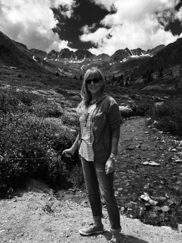
And wouldn't this have been a great pic if someone hadn't accidentally 
put the black and white filter on their phone camera?!
All those flowers behind me....o well.  


The flowers were gorgeous. There were tiny white butterflies everywhere. The dogs frolicked. The people frolicked. There were waterfalls and baby Big Horn Sheep. It was a glorious day. 


A little waterfall

                 
See why it's called a basin? 

                                 
Wildflowers...

                                 
and more wildflowers....

Mama Big Horn Sheep with Baby (Not So) Big Horn Sheep


No. 71 has had its basket emptied.


* photo by Lauren Murray...thanks! Lauren!